

Into the Ionian

We headed west to mainland Greece and found the bitter end of a pier in Gefyra to tie up to. This is a small village with a causeway and bridge that extends over to Monemvasia - which was our destination. Tom had visited 33 years ago with his mother, who was living in Greece at the time, and he wanted to return. It happened to be our 32nd anniversary.


Gefyra is 320 km south of Athens down the Peloponnese peninsula. Monemvasia, which means ‘single entrance’, is a fortified city on an isolated rock that lies just off the coast. It consists of a narrow strip of land by the sea, with tall cliffs forming a large sloping platform at the top. Originally this was the location of the upper city, but now only the walled lower city exists on the south side of the island, invisible from the mainland. The history here is rich and complicated. It has Venetian and Byzantine churches as well as Ottoman architecture, such as a mosque and hamam. In the Medieval era, it had periods of tremendous prosperous trade as well as disastrous sacks. Some say that Monemvasia was found in the late 6th century. Invaded by the Normans and Arabs and shifting under Byzantine, Venetian and Ottoman rule, it wasn’t until 1821 that it was liberated and became part of the Greek state.


Labyrinthine Hike
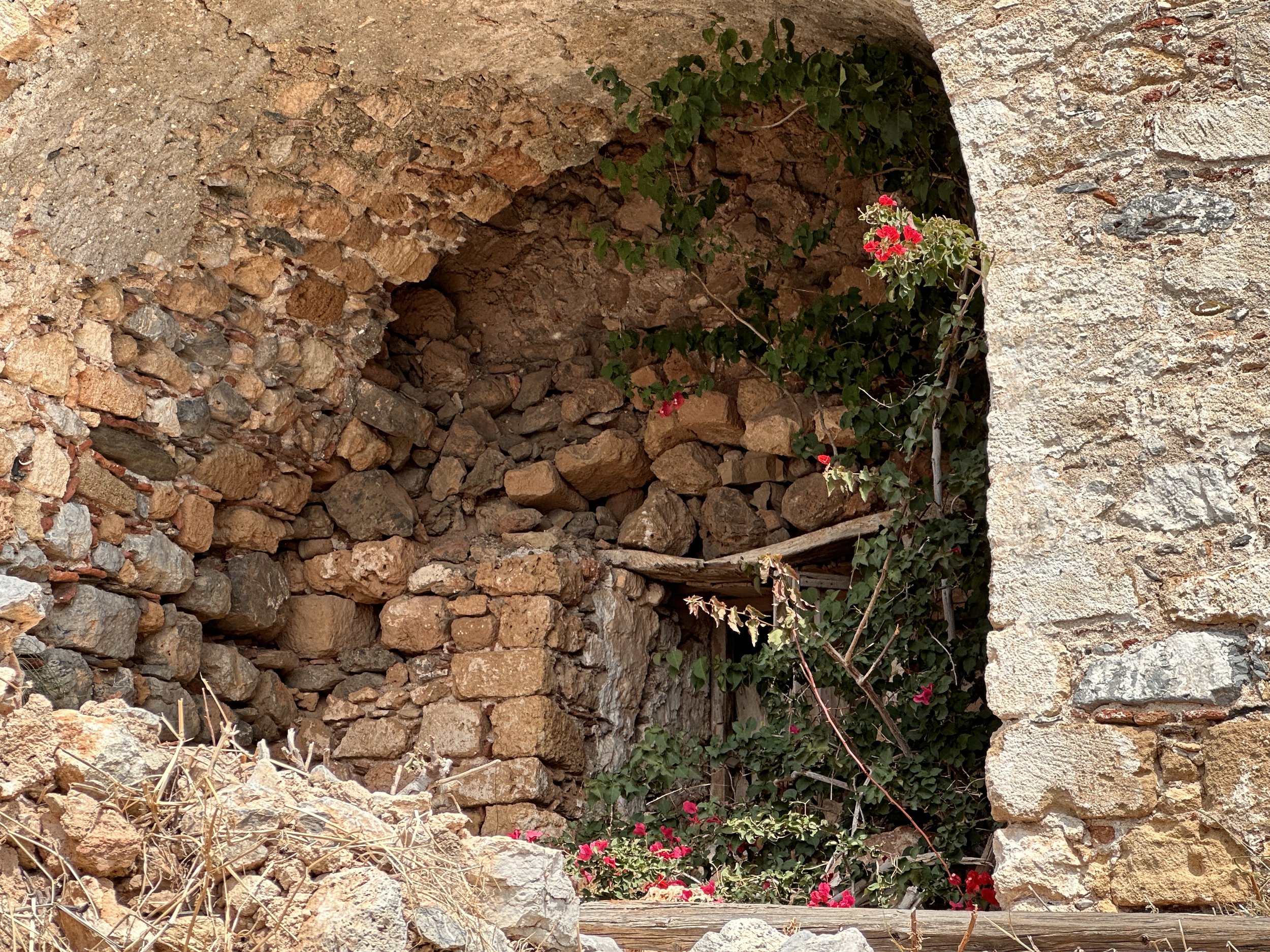
We walked from the harbor across the causeway and spent the day exploring the cobbled streets and stone buildings - many of which have been turned into boutique hotels. We then hiked up above the walled community and clambered over the remains of the upper city. The views of the mainland, the islands and sea were spectacular.


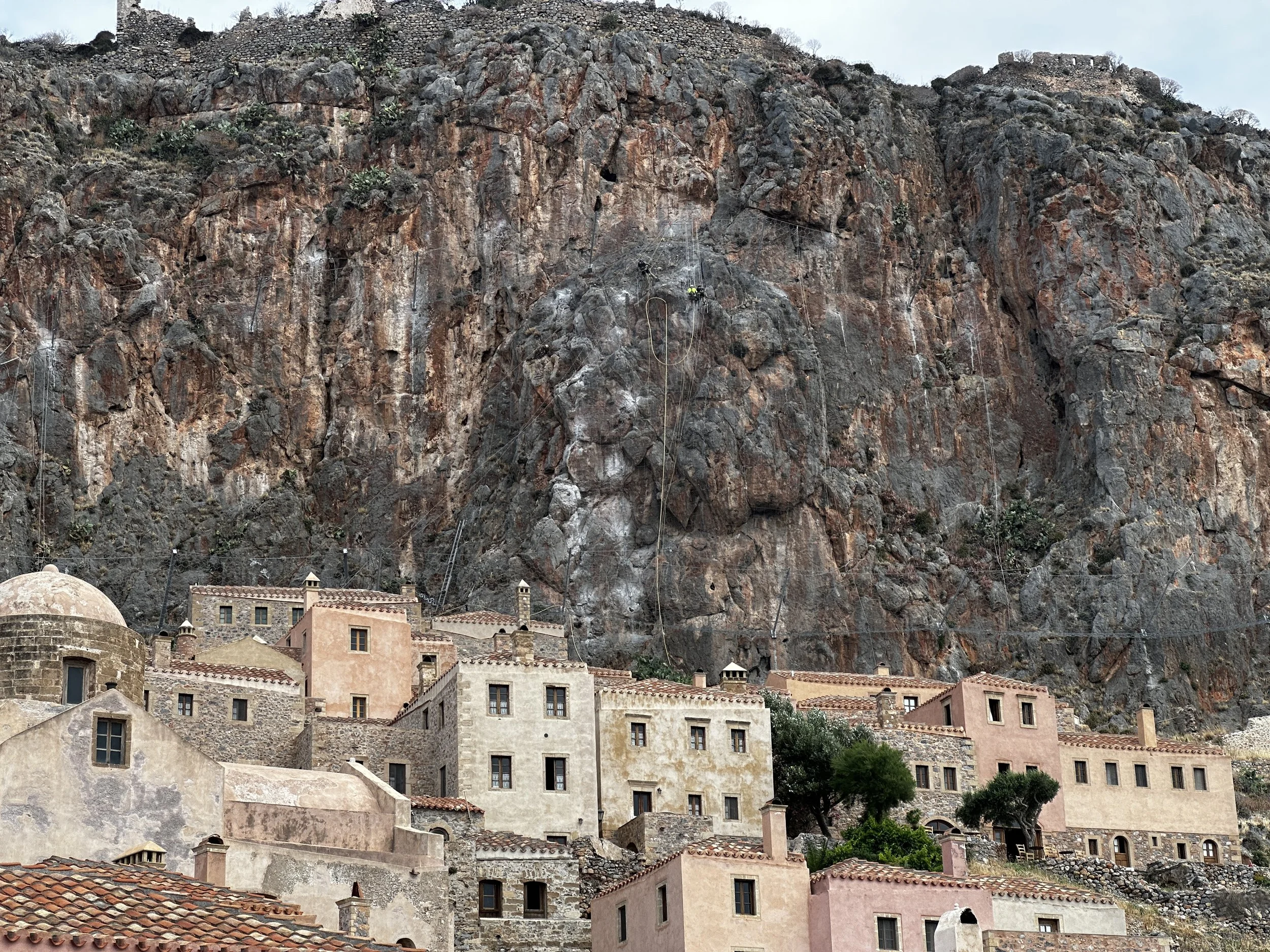


Fresh water was of great concern -- large community cisterns (and some smaller private ones) captured the runoff.

“Christmas Cove” dawn
The following day we headed north. We passed through an area we’d visited in December and reminisced about our week with the kids over the holidays. We anchored that night in what I call “Christmas Cove” as we swam there in December when the water was quite brisk! The next day we continued north hoping to anchor near the Corinth Canal. We needed to figure out how to make the crossing and when we would be permitted. The canal was closed the beginning of 2021 after a landslide. It re-opened in June 2022 until October 2022. After further remediation, the canal again reopened on June 1st of this year.
It was now June 3rd. We weren’t sure if there might be a backlog of vessels waiting to transit. We arrived mid-morning and radioed for information. We were instructed to tie up at the terminal and bring our papers inside. Upon reviewing our documents we were asked if we wanted to cross today or tomorrow. Somewhat startled, we shrugged and said “today”!
Vessels using the canal pass in a convoy using a one-way system which is monitored in two towers, one at each end. We waited for a large tanker and tug to emerge heading east and 40 minutes later it was our turn. Six other boats had arrived by then and we were instructed to enter single file as a group. You must maintain a certain speed in the canal to insure traffic is continually moving. The entire transit takes about 30 minutes.
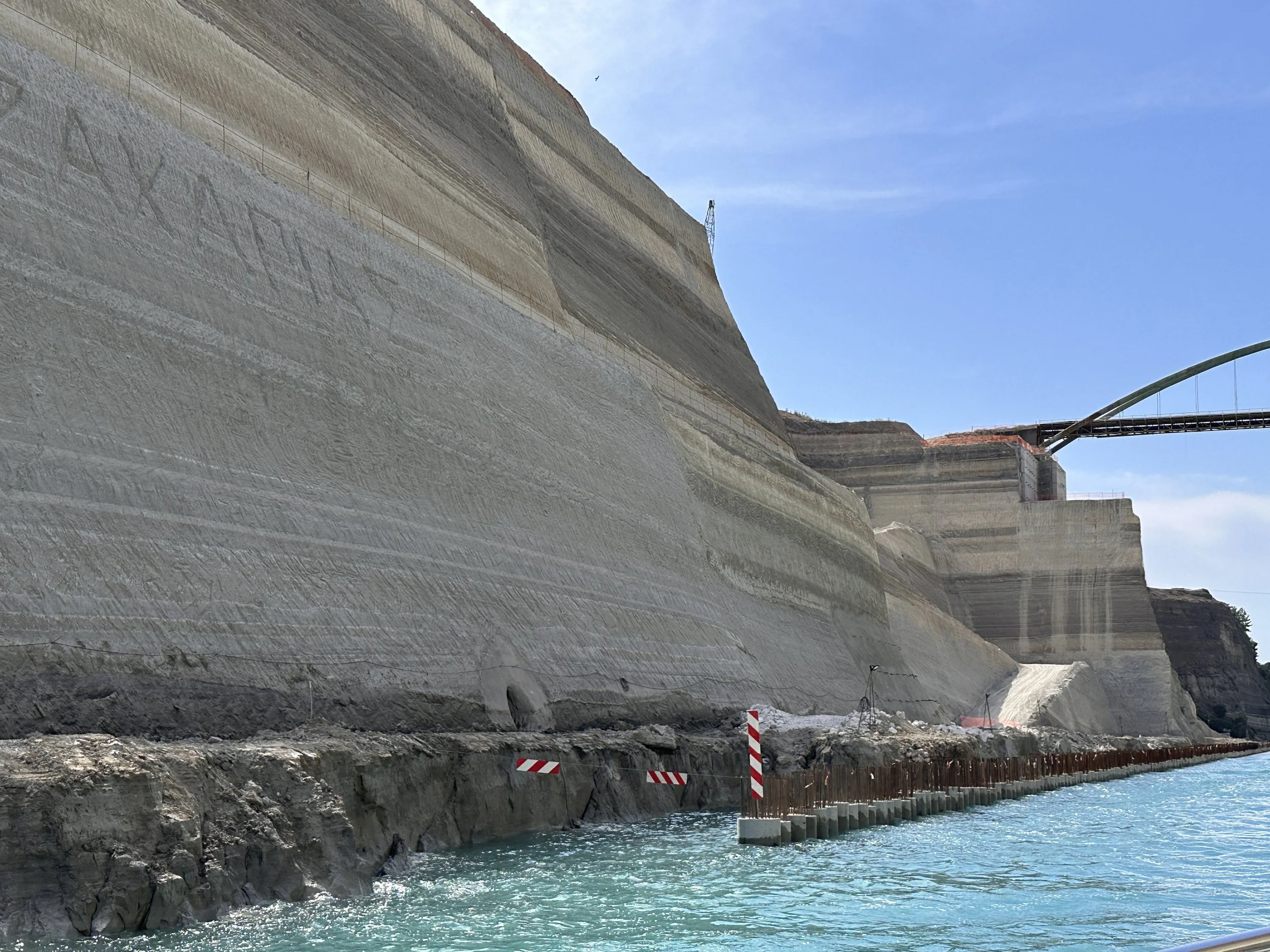
Although the Corinth Canal is a mere 125 years old, several rulers in classical antiquity thought of digging a channel through the narrow strip of land that connected the Peloponnese to the rest of the mainland. Periander, tyrant of Corinth at the end of the 7th and beginning of the 6th century BC, was the first to come up with the idea of such a canal.
Over the centuries, of most concern was the difference in water levels between the Gulf of Corinth and the Saronic Gulf, fearing the current inside the canal would be much too strong for safe navigation. Recent research has indeed shown that the levels of the two gulfs have varied a lot in the course of time, so this was no mistake by the ancient engineers.
The idea was revisited time and time again by the Romans, the Venetians and the Greeks. Centuries later, the opening of the Suez Canal in 1869 made the Greek government re-assess the possibility and soon after, a law was passed allowing the construction of the Canal of Corinth as we now know it. The construction began in April 1882 and after 11 years of hard work, on July 25th 1893, the first ship navigated directly from the Corinthian into the Saronic Gulf.
The canal was constructed at sea level so no locks would be necessary. It is 26 feet deep (8 meters) and 4 miles (6.3 kilometers) long. At the top of the rock walls, 295 feet (90 meters) above sea level, it is 80 feet (24.6 meters) wide narrowing just slightly to 70 feet (21.3 meters) wide at the bottom. The walls form a near-vertical - 80 degree angle.
It is currently crossed by two railway lines, three roads, a footbridge, and a motorway. In 1988 two submersible bridges were installed at each end. When ships enter, the bridges are lowered vertically using an elevator-like system until they completely disappear under the water and vessels can pass over them. Nowadays the canal is mostly used by tourist ships, yachts, and some smaller cargo ships. In 2014 approximately 11,000 ships used the canal's shortcut through the country instead of navigating the 435 miles (700 kilometers) around the Peloponnese.


We exited the canal into the Gulf of Corinth. The seas were calm and although we’d imagined stopping for the night just south of the entrance, the area was quite industrial and we decided to cross the narrow bay and drop anchor on the other side. Two hours later we were being tossed all over creation by a huge swell. Unable to cook dinner, or for that matter – sit comfortably, I finally gave up and insisted we return to the anchorage by the canal. Another hour later, just before sunset, we were finally settled for the night.
We set off the next morning for Návpaktos on super flat water and crossed the full length of the gulf - 60 nautical miles. We dropped anchor with a couple of sailboats outside of a medieval harbor in the shadow of a Venetian castle. We would have liked to explore this little hamlet and the castle above but we felt we needed to keep moving.
Just five miles away stands the Rion Bridge. It spans the western entrance to the Gulf of Corinth and is but one mile wide. This is the longest cable-stayed bridge in the world and is supported by four pillars providing three navigable channels. Yachts must call Rion Bridge Traffic to obtain permission to transit beneath. You are then instructed which span to transit and are asked to confirm understanding before proceeding. Notwithstanding the busy traffic on the bridge, car ferries continually cross from side to side beneath it, so despite being given the okay to transit you must keep a discerning eye out for ferries. It is another 25nm out into the Ionian Sea.


We spent the night in the back of a deep bay on Ithica Island where we went for a dip and relaxed before settling in for the night. The next day we cruised on to Levkas Island. Though I had read about high winds and intense weather conditions between the islands and the mainland, the inside corridor of the North Ionian Sea seemed like a large lake. Not only was the water barely rippled and the breeze nearly non-existent, but I discovered butterflies - yes, butterflies, flittering across our bow. Even at over 12 miles offshore there were dozens of butterflies! I was astounded. I believe they are Cleopatra butterflies, though I was never able to capture a good photo. The Ionian Islands have considerably higher rainfall in comparison with the drier islands of the Aegean. Perhaps this allows for these beauties to thrive here.

I passed my time observing the sea birds as well. Completely nonplussed by our purring engines the Yellow-legged Gulls seemed to await our arrival as we motored towards them. I found great joy sitting on the bow and watching them take-off, circle and dive, resurface and land again.
We stopped at a marina on Lefkas as we needed to do some routine maintenance and reprovision. Lefkas is an island only because of a canal which separates it from the mainland. Most of the island is covered with steep limestone mountains while the northern end is surrounded by a flat salt marsh. The Lefkas canal cuts through the marsh and provides passage for boats down the eastern side of the island. We spent three days there catching up on chores and maintenance, walking, and restocking. We, naturally, visited the chandlery and in addition to a few spare parts we needed, we also picked up a new toy.


We left Levkas and headed for Corfu. This is where we would check-out of Greece after a month of cruising it's beautiful waters. We hired an agent to do our clearance paperwork and a marina seemed prudent to aid in this process. Upon approach to the largest marina we'd ever seen (1200 boat capacity) we noticed a Nordhavn 56 Motorsailer on anchor beneath Corfu Castle. Only eight of these beautiful boats were ever built (2009-2010). We wondered about how it ended up in the Mediterranean. We were just rounding the next point into our marina when a small dinghy with two people aboard began barreling straight towards us. I went out on the back deck to see what the heck they were doing. The man maneuvered his dinghy alongside us and shouted that he owned a Nordhavn 56 Motorsailer which was anchored in the next bay and that Meraki was the first Nordhavn 41 he'd ever seen. We agreed to catch up with each other the next day so that we could each show off our boats.


The next morning we were invited over to their yacht for brunch. We spent several hours chatting, eating and getting to know one another. Later we took a short dinghy ride up a small estuary to a grocery store, and then motored around the cape into Gouvia Marina to show them Meraki.
It ls always fun to meet fellow boaters and hear their stories. I always learn a few lessons as well. Cruisers typically talk about good anchorages, where to find the best bakery, and what's their solution to your latest boat issue. We generally share a love for the outdoors, exploration and adventure, marine life and meeting new challenges. These memories remain etched in my mind and make this life so enriching.
Note:
Not all subscribers received our last post. Please check on the Blog tab above if you have not heard from us in awhile.
Photo captions will not appear if viewing on a cell phone.